
Erving, Wendell residents say less is more on proposed shared-use path

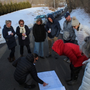
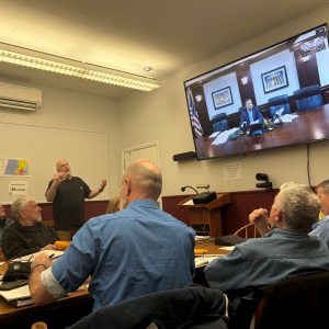
Residents of both Erving and Wendell expressed their interest in a shared-use path to connect the two towns during a community engagement session this week at the Erving Senior & Community Center and provided feedback seeking a “less is more” approach. STAFF PHOTO/ERIN-LEIGH HOFFMAN
| Published: 01-24-2025 4:12 PM |
ERVING — Residents of both Erving and Wendell expressed their interest in a shared-use path to connect the two towns during a community engagement session this week and provided feedback seeking a “less is more” approach to constructing the path for bicyclists, pedestrians and some vehicles.
According to a presentation by project engineers Green International Affiliates Inc., the roughly 5-mile shared-use path would start by Farley Flats before going through Erving Center and into Wendell Depot, providing a safer route for bicyclists and pedestrians than the existing Route 2 roadway. A feasibility study is looking at the options available to create the path.
This project to provide an alternative to Route 2 has been a goal for the town of Erving and other municipal bodies since 2002, when the Erving Master Plan, which included the idea for this path, was approved by voters.
Now, Green International Affiliates has contracted with Erving after the town received a $30,000 MassTrails grant in June 2024 for the study.
“This is a feasibility study, so anything you see here today is obviously not final,” Green International Associates Project Manager Nick Millhollin said during Wednesday’s community engagement session.
Millhollin later explained that while these design options aren’t final, they are providing options for residents to avoid the high speeds and narrow roadways on Route 2.
“You see vehicles traveling in excess of 60 mph,” Millhollin said. “You don’t want to be riding your bike right next to that.”
The presentation showed on a color-coded map that labeled the proposed path in five phases, starting from Wendell Depot Road, extending through the Wendell State Forest down to Farley Road, crossing the Millers River over to Maple Avenue, continuing to Old State Road and connecting to existing Route 2 bike accommodations. Phase 3 also contains two alternate route options to account for the Millers River crossing where the historic bridge is located. Other phases also have alternate routes and designs.
Article continues after...
Yesterday's Most Read Articles
 Greenfield native Sam Calagione, founder of Dogfish Head Brewery, to throw out first pitch at Fenway Park on Friday
 Whately cyclist struck by vehicle in Deerfield
 Residents opposing Deerfield dog shelter gain attorney as public hearing is continued
 Report: Montague Police internal affairs investigation ‘biased’
 Testimony argues against need for Greenfield cell tower
 UMass vice chancellors: ICE not on campus
Each of these phases includes a description of the type of path, whether it would accommodate vehicle access, only bikes and pedestrians, or both. Additionally, Phase 1 offers a parking location for vehicles on Sears Road to the east and Arch Street to the west. Photos presented show existing conditions in Erving and Wendell where the shared-use path would be built, as well as design alternates. In all phases, the path would be around 8 to 10 feet, with shoulders or buffers available to separate vehicles and bikes, or pedestrian walkways and bike lanes.
Following the presentation, attendees had the chance to ask questions about construction of the shared-use path, how residences along the path would be impacted, how existing bylaws and regulations will influence design, who would be responsible for path maintenance and more.
Regarding construction of the path, one of the main themes focused on how to preserve the nature of the areas in Erving and Wendell, and not make the path overly cumbersome in its width and design.
“I think what you’re hearing from a group of us is less is more,” said Ed Hines, president of the Wendell Historical Society, adding later that he feels the path will find more success among residents that way. From a historical perspective, Hines mentioned Bear Mountain, where Native American and settler artifacts are present, along with the historic bridge.
Erving Selectboard member Scott Bastarache said he had a vision of the path similar to that of Wendell resident Dale Kowacki, which included a smaller width by prioritizing the shared-use paths in the designs, rather than creating separated lanes for vehicles. Additionally, Bastarache asked if there is a way to allow for the “natural appeal” of the area compared to other paths he’s seen before.
“There’s certain give and take to it, but keeping that in mind instead of creating 20-foot swaths to get all separate lanes, is there a majority of this that could be considered if there needs to be a vehicle access point? Could it be mixed-use as the primary?” Bastarache asked. Millhollin said this is something that Green International Associates can consider in future designs.
Town Administrator Bryan Smith and Millhollin explained the next steps are to complete the feasibility study, which includes the considerations of feedback from residents, and present it to the state in June 2025. Additionally, a survey will be sent to attendees and posted on the Erving town website for residents to fill out.
No funding has been secured yet for the construction of the path, and Millhollin said he will keep the town updated if further opportunities for public comment arise.
For an overview of the proposed shared-use path, visit erving-ma.gov/community-planning/pages/blue-heron-greenway-feasibility-study.
Erin-Leigh Hoffman can be reached at ehoffman@recorder.com or 413-930-4231.
 Greenfield Police Logs: March 25 to April 6, 2025
 Catholic Charities loses funding for refugee programs, shifting focus under new leader
 Reported cuts to Head Start program have Community Action worried about consequences
  Photos: Ready Readers